
The Arctic Circle in Norway
The Arctic Circle is a line of latitude rather than a physical border. In Norway it crosses Nordland, north of Mo i Rana, connecting a point on a map with the changing experience of daylight through the year.
A line shaped by Earth’s tilt
Its latitude is approximately 66 degrees 33 minutes north. The circle’s position is related to the tilt of Earth’s rotational axis. Because that tilt changes slowly, the precise latitude is not permanently fixed.
In a simplified geometric model, the circle marks the boundary associated with at least one day of midnight sun and one day without sunrise. Actual observations are more complicated: atmospheric refraction, the Sun’s visible size, and the local horizon affect what can be seen.
Why monuments mark the crossing
A monument turns an invisible geographical idea into a place where people can stop and look. Norway has markers associated with Arctic Circle crossings, including coastal and inland settings. The marker is a reference to the line, rather than something that creates or controls it.
A photograph or illustration of a monument needs its own location evidence. A general Arctic Circle theme should not automatically be assigned to one particular roadside or coastal site.
Time, light, and a northern landscape
The subject has a special relationship with a clock. The clock measures passing hours, while the Arctic Circle invites questions about how those hours look in different seasons. Our related design explores the monument theme as a reminder of northern geography and the changing relationship between daylight and daily life.
Explore related clocks
-
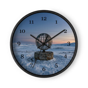
Arctic Circle Monument
$54.99 Select options This product has multiple variants. The options may be chosen on the product page